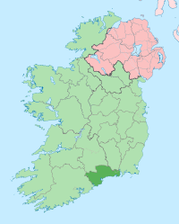
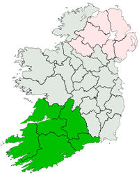
County Waterford
County Waterford (Irish: Contae Phort Láirge) is one of the twenty-six counties of the Republic of Ireland, and also one of the thirty-two counties of Ireland, located within the province of Munster. It was named after the city of Waterford (which derives from the Old Norse name Veðrafjǫrðr or Vedrarfjord). Dungarvan is the administrative centre of County Waterford. Waterford is the 21st largest of Ireland’s 32 counties in area and 20th largest in terms of population[1]. It is the smallest of Munster’s 6 counties in size and smallest in terms of population.
Geography
County Waterford has two mountain ranges, the Knockmealdown Mountains and the Comeragh Mountains. The highest point in the county is Knockmealdown, at 794m. It also has many rivers, including Ireland's third longest river, the River Suir (184 km); and Ireland's fourth longest river, the Munster Blackwater (168 km). There are over 30 beaches along Waterford's volcanic coast line. A large stretch of this coastline, known as the Copper Coast has been designated as a UNESCO Geopark, a place of great geological importance. The area around (An Rinn) is a Gaeltacht, an Irish-speaking area.
Déise
County Waterford is known locally as "The Déise" (An Déise). Some time between the 4th and 8th centuries, a tribe of native Gaelic people called the Déisi were driven from the southern parts of the country, conquering and settling here. The ancient principality of the Déise is today roughly coterminous with the current Roman Catholic Diocese of Waterford and Lismore. The Deise has a rich history from megalithic tombs and ogham stones, to Vikings, to remnants of English occupancy, including the Gaulstown dolmen, Reginalds Tower and the Ballysaggartmore Towers respectively. The people that live in the Déise today are known to thrive on Irish traditions such as hurling and gaelic football and Irish traditional music. The westernmost of the baronies of county Waterford are "Decies within Drum" and "Decies without Drum", separated by the Drum-Fineen hills.[2]
Towns & Villages
| Historical populations |
| Year |
Pop. |
%± |
| 1653 |
13,136 |
— |
| 1659 |
13,286 |
1.1% |
| 1821 |
76,103 |
472.8% |
| 1831 |
85,217 |
12.0% |
| 1841 |
196,187 |
130.2% |
| 1851 |
164,035 |
−16.4% |
| 1861 |
134,252 |
−18.2% |
| 1871 |
123,310 |
−8.2% |
| 1881 |
112,768 |
−8.5% |
| 1891 |
98,251 |
−12.9% |
| 1901 |
87,187 |
−11.3% |
| 1911 |
83,966 |
−3.7% |
| 1926 |
78,562 |
−6.4% |
| 1936 |
77,614 |
−1.2% |
| 1946 |
76,108 |
−1.9% |
| 1951 |
75,061 |
−1.4% |
| 1956 |
74,031 |
−1.4% |
| 1961 |
71,439 |
−3.5% |
| 1966 |
73,080 |
2.3% |
| 1971 |
77,315 |
5.8% |
| 1979 |
87,278 |
12.9% |
| 1981 |
88,591 |
1.5% |
| 1986 |
91,151 |
2.9% |
| 1991 |
91,624 |
0.5% |
| 1996 |
94,680 |
3.3% |
| 2002 |
101,546 |
7.3% |
| 2006 |
107,961 |
6.3% |
| [3][4][5][6][7][8] |
- Abbeyside, Affane, Aglish, Annestown, An Rinn, Ardmore
- Ballinacourty, Ballinameela, Ballinamult, Ballinroad, Ballybeg, Ballybricken, Ballyduff Lower, Ballyduff Upper, Ballydurn, Ballygunner, Ballylaneen, Ballymacarbry, Ballymacart, Ballynaneashagh, Ballysaggart, Ballytruckle, Bilberry, Bunmahon, Butlerstown
- Cappoquin, Carrickbeg, Carriglea, Cheekpoint, Clashmore, Clonea-Power, Clonea Strand, Colligan, Coolnasmear, Crooke
- Dungarvan, Dunhill, Dunmore East
- Faha, Faithlegg, Fenor, Ferrybank, Fews, Fourmilewater
- Glencairn, Grange
- Helvick Head
- Kilbrien, Kilgobinet, Kill, Killea, Kilmacthomas, Kilmanahan, Kilmeaden, Kilrossanty, Kilwatermoy, Kinsalebeg, Knockanore
- Lemybrien, Lisduggan, Lismore
- Mahon Bridge, Mine Head, Modeligo, Mothel, Mount Congreve, Mount Mellaray
- Newtown
- Old Parish
- Passage East, Portlaw
- Rathgormack
- Sliabh gCua, Stradbally
- Tallow, Tramore, Touraneena, Tourin, Tycor
- Waterford, Whitechurch, Whiting Bay, Woodstown
- Villierstown
Location Grid
See also
- List of abbeys and priories in the Republic of Ireland (County Waterford)
- Saint Declan
References
- ↑ Corry, Eoghan (2005). The GAA Book of Lists. Hodder Headline Ireland. pp. 186–191.
- ↑ Egan, P.M. (20 November 2004) [1893]. "Early Waterford History 2. The Decies". History of Waterford. http://www.waterfordcountymuseum.org/exhibit/web?task=Display&art_id=184&pagenum=2. Retrieved 2008-02-23.
- ↑ For 1653 and 1659 figures from Civil Survey Census of those years, Paper of Mr Hardinge to Royal Irish Academy March 14, 1865.
- ↑ Census for post 1821 figures.
- ↑ http://www.histpop.org
- ↑ http://www.nisranew.nisra.gov.uk/census
- ↑ Lee, JJ (1981). "On the accuracy of the Pre-famine Irish censuses". In Goldstrom, J. M.; Clarkson, L. A.. Irish Population, Economy, and Society: Essays in Honour of the Late K. H. Connell. Oxford, England: Clarendon Press.
- ↑ Mokyr, Joel; O Grada, Cormac (November). "New Developments in Irish Population History, 1700-1850". The Economic History Review Volume 37 (Issue 4): 473–488. doi:10.1111/j.1468-0289.1984.tb00344.x. http://www3.interscience.wiley.com/journal/120035880/abstract.
External links
|
Mountains and hills of Munster |
|
| List of mountains in Ireland |
|
| Ballyhoura Mountains |
Carron Mountain • Seefin
|
 |
|
| Boggeragh Mountains |
Musheramore
|
|
| Caha Mountains |
Hungry Hill • Sugarloaf
|
|
| Comeragh Mountains |
Fauscoum
|
|
| Derrynasaggart Mountains |
Mullaghanish
|
|
| Dingle Peninsula |
Benoskee • Brandon
|
|
| Galtee Mountains |
Galteemore • Lyracappul
|
|
| Iveragh Peninsula |
Bentee
|
|
| Knockmealdown Mountains |
Knockmealdown • Sugarloaf Hill (Knockmealdowns)
|
|
| Macgillycuddy's Reeks |
|
|
| Mangerton Mountains |
Mangerton • Torc Mountain
|
|
| Shehy Mountains |
Knockboy
|
|
| Silvermine Mountains |
Slievekimalta
|
|
| Slieve Mish Mountains |
Bartregaum • Caherconree
|
|
| Slieve Miskish Mountains |
Knockoura
|
|
| Others |
An Triúr Deirfiúr • Devil's Bit • Geokaun Mountain • Mount Gabriel • Mullaghareirk Mountains • Purple Mountain • Slieve Aughty • Slievecallan • Slievenamon
|
|